Author: Projeto Nova Cartografia Social da Amazônia – Alfredo Wagner Berno de Almeida, Sheilla Borges Dourado, Carolina Bertolini Website: novacartografiasocial.com

An atlas of countercartography
Through the use of social mapping techniques, the research work of the New Social Cartography of the Amazon Project (PNCSA)1 seeks to analyze the differentiated processes of territorialization which are currently underway in the Amazon region. In doing so, the work focuses on the relationship between these processes and the emergence of collective identities embedded in social movements. These identities are multiple and make up an often overlooked Amazonian socio-cultural diversity. The different collective identities are held together through local denominations such as: riverside dwellers (ribeirinhos), rubber tappers (seringueiros), maroons (quilombolas), indigenous peoples, piassaba palm extractors (piaçabeiros), small-scale fishers (pescadores artesanais), nut collectors (castanheiros), artisans (artesãos and artesãs)2, urban indigenous communities, babassu coconut collectors (quebradeiras de coco babaçu) and collectors of açaí fruit (peconheiros).
Each of these categories of identity defines itself according to its organizational form. Through successive mobilizations they construct their own specific territories. Through a growing cultural self-awareness they have mobilized forces in order to defend their territories from predatory commercial interests. Companies that seek commercial interests are mostly responsible for environmental devastation in the Amazon, especially deforestation and contamination of water resources. For this reason, social movements have carried out campaigns against loggers, large farming and cattle ranching projects, iron-ore plants and mining companies.
The central issue is that indigenous and maroon lands, like those effectively controlled by traditional peoples and communities, are currently threatened by this expansion. The threat derives from the fact that these traditional peoples and communities live and occupy areas of great environmental preservation and significant vegetation cover. Social mapping produced by communities about their own territories translates this strong environmental consciousness and its effects into cartographic representations.
The objective of PNCSA is to map these popular mobilization forces while describing and geo-referencing them based on what is considered to be relevant by the studied communities themselves. At the same time the mapping work presupposes training and capacity building of members of these communities. Teaching the community members about constitutional provisions, pertinent environmental legislation and the use of elementary GPS techniques makes up an initial stage of the PNCSA work. Such capacity building is consolidated through the mapping workshops carried out in the communities themselves. In accordance with a composition defined by their own members, these workshops result in activities that delimit perimeters and solidify information obtained through direct observation and from different kinds of stories. This contributes to a sufficiently precise ethnographic description. Throughout the fieldwork we verified the recurrent use of the expression “traditionally-occupied lands”3 in the lists of the social movements’ demands. This was a constant reference, and it may indicate a growing perception of these social agents in regards to violations of their territorial rights.
Social movements that demand the recognition and protection of human rights regarding special identities in urban areas are partners in social cartography as well. Representatives of other
minority groups, such as lesbians, gays and transgender activists in Manaus, also produced their maps, through which they intended to become visible to the State and other social agents.
In order to facilitate wide dissemination, the results of the work are published in the form of booklets (fascículos) containing maps, excerpts from narratives created by members of researched communities as well as the group’s demands. The members of the mapped communities mainly distribute these booklets themselves.
PNCSA has also been establishing itself through an articulation from researchers belonging to higher education institutions on the one hand and participants of social movements in the Pan-Amazon on the other hand. As of today, their main goal is to strengthen territorial rights of traditional peoples and communities.
So far the maps have become supportive instruments managed by traditional peoples and communities for demands addressed to the State as well as for demands against the State. The maps are produced by members of the communities themselves through the mapping workshops that take place within the community. They have become technical resources that ensure accuracy and precision regarding the boundaries of the territories proposed by community associations and social movements.
Since the publication of the book Carajás: The War of Maps (Almeida, 1994) we have been consolidating the basis of the New Social Cartography. The critical aspect is the evidence that there is an internal conflict in the lexicon inside the field of knowledge on social cartography. In this sense, the term “New” in the expression New Social Cartography corresponds to a critical analysis of the conventional use of other similar expressions like “participatory mapping”, “collaborative mapping” or “cultural mapping”, used by the World Bank or by big enterprises like Google, megaprojects and NGOs. These mappings correspond to practices in which the “participation” of traditional people and communities is commonly restricted to limits, and sometimes these limits turn “participation” into mere “ratification” of decisions taken by someone else.
As mentioned earlier, the research experiences of the PNCSA focus on diverse situations in which social agents use their ethnic identities in order to categorize themselves and others with the goal of interacting and forming political collectives in an organizational sense. Ethnicity thereby serves as a collective mode of action and representation. We have focused the fieldwork and analyses on the ethnic boundaries that define groups and not on the cultural content that they express. They reflect a new reality and more precisely the tendency of groups to invest deeply in a collective identity in order to demand rights that are essential to their physical and cultural reproduction. This new reality appears to be associated with the self-definition of social agents and their condition as legal subjects.
In accordance with PNCSA techniques, one could say that the situational maps refer to concrete occurrences of conflict in regions which are already delimited with relative precision. The goal is to delimit specific territorialities, providing conditions for a more detailed description of the elements considered relevant by the members of the studied communities in order to make up a cartographic base. In this sense they are different from thematic
maps since they consider sketch-maps as being part of the choices made by social agents in order to compose the maps that should be included in the booklet4.
The situational map explains the dynamic character of the mapped realities. It reflects the communities’ points of view at a given moment and may also present changes depending on the processes taking place in the territories and the perceptions of the members of the mapping communities.
The work of social mapping thus includes two aspects: an ethnographic one, which requires academic work, direct observation techniques, detailed descriptions and criteria to select information, and another one carried out by the social agents themselves, defining the use of instruments, their choice, the selection of what is included in the map. PNCSA not only contributes to the training of social agents, but also respects their autonomy of practice. Therefore, the decisions are left to the local communities after they have learned techniques to tie together GPS points and other basic technical resources. They can decide whether to include or exclude information which is not regarded intrinsic or which is confidential. This is not a purely quantitative mapping of certain vegetation types, biomes or ecosystems. It is rather a social mapping that produces material, termed situational maps. They are distinguished from participatory maps. Because participatory maps, such as planning instruments, are defined by planners in order to incorporate communities in decisions which are made for them or will affect them. Unlike these maps, our social mappings work in favor of social movements and collective identities as well as intrinsic organizational forms (of mobilization and solidarity) adopted by the groups themselves (Almeida, 2013: 157-173).
Manual work is usually seen separately from intellectual work. We, on the contrary, believe that both forms of work are considered intellectual work. Besides, other traditional people, communities, indigenous and maroons have also become capable of using a GPS or software like ArcGIS. The use of these technological tools combines the technical competence with the community’s interests. In this context, the technical expertise provided by universities in producing maps together with communities is associated with the “militant capital”5 belonging to associations and representations of peoples and communities. This combination considerably broadens the spectrum of map production and profoundly redefines the current use of “participation” in social mapping.
This way, traditional communities become a source of information production. In continuation, traditional communities may also be able to monitor their own territories in the near future. They will be able to manage it in real time, despite of difficulties, such as the need to learn how to interpret satellite images or challenges, such as finding clear images of the Amazon region due to constant cloud cover. In response to this impediment, the use of drones has been pointed out as a solution for obtaining better imagery.
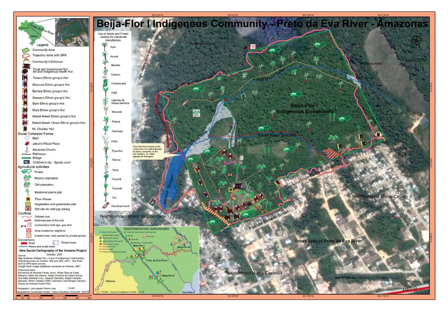
In many situations the maps and booklets functioned as a pressure device, demonstrating the weakness of official decisions and showing evidence of the gaps in which municipal leaders could intervene. In this sense, the recourse to ethnography provides scientific authenticity to indigenous demands. In Jambuaçu (Pará), where maroons suffered serious damages from the explosion of a mineral pipeline inside their villages, the booklet was used in the judicial process requesting compensation for environmental damages. Within their urban perimeter, the indigenous people of the Beija-Flor Community, Rio Preto da Eva (Amazonas), pressured the municipal government to expropriate the area and grant it to them – after decades of conflict. In the municipal councils of Rio Preto da Eva and Novo Airão (Amazonas) indigenous members, maroons and riverside dwellers held up their hands showing the booklets they produced themselves. The booklets are seen as documents that show the evidence of their territories. In the case of Novo Airão, the areas set aside for the Jaú National Park overlap the remnant areas of maroons in Tambor. The maroons appreciated the experience of producing that map, which became a required reference document for anyone interested in understanding the dynamic of the conflict. They released the booklet in the Municipal Council of Novo Airão in order to make their territorial demands public.
Following this and through their use for political mobilization, the maps were transformed into instruments of struggle once they focused on territorial and ethnic rights. In the conflict between the maroons from Alcântara (MA) and the Brazilian Space Agency (AEB), the intrusion on maroon territory was ethnographically documented by a historian and by agricultural technicians who were also members of maroon families having been displaced in 1986. These professionals attended technical training courses provided by PNCSA and carried out all the mapping work. We have witnessed an undeniable political dimension, which organizes demands through the construction of the maps themselves, making this work support mobilization and reinforcement of ethnic identity.
The work of PNCSA has been carried out since 2005 through processes of politicization and criticism of geographisms (approaches that restrict the territory’s mapping exclusively to a physical dimension) as well as the old vision of biologized agents (representing the acting subject from an exclusively biological or genetic point of view). The mediator’s position assumes a new form, and academic participation takes place through criteria of competence, expertise and scientific wisdom. There is an intellectual division of labor that requires acuity in the elaboration of maps and booklets. Research relations have been patiently constructed, especially given that this is a period of attempts to institute new rules of tutelage (legal subordination to a tutor) through the redefinition of strategies by many NGOs (Almeida 2008a: 105). Renewals among social movement leaders on a large scale have also played an important role.
In all of the situations studied, a recurring point of critique refers to the “personification of collectives” (Micelli, 2007), which is evident in phrases such as: “Indigenous people think that…” or “Peasants don’t accept that…”. We avoided to reproduce these commonplaces and decided to publish a list of those presented in map workshops, showing the authorship of the correspondent talks. The booklets therefore have multiple authors. Another difficulty concerns the attempts to usurp political representation by traditional peoples and communities, which leaves the action of mediators open to constant questioning.
In this respect, social mapping represents an instrument that strengthens the emergence of collective identities and at the same time balances out the emphasis on biodiversity. This focus on natural elements usually appears in environmentalist speeches regarding the Amazon region.
Therefore, social mapping creates ties to cultural diversity and to the mobilization of traditional peoples and communities regarding territorial and cultural rights.
Almeida, A.W.B. de, Shiraishi, J. & Martins, C.C. 2005. Guerra Ecológica nos Babaçuais: O Processo de Devastação dos Palmeirais, a Elevação do Preço de Commodities e o Aquecimento do Mercado de Terras na Amazônia. São Luís: MIQCB.
Almeida, A.W.B. de 1994. A guerra dos mapas. Belém: Falangola.
Almeida, A.W.B. de 2008a. Antropologia dos’ Archivos’ da Amazônia. Rio de Janeiro: Casa 8.
Almeida,A.W.B. de 2008b.Terras de Quilombo,Terras Indígenas,‘Babaçuais Livres’,‘Castanhais do Povo’, Faxinais e Fundos de Pasto:TerrasTradicio- nalmente Ocupadas. Manaus: PPGSCA/UFAM
Almeida,A.W.B.de2013.NovaCartografiaSocial:territorialidadesEspecífi- cas e Politização da Consciência das Fronteiras. In Almeida, A.W.B. de & Almeida Farias Júnior, E. de, eds. Povos e Comunidades Tradicionais. Nova Cartografia Social. Manaus: UEA Edições: 157-173.
Bourdieu, P. 1998. Contrafogos:Táticas para Enfrentar a Invasão Neoliberal. Rio de Janeiro: Jorge Zahar Editor.
Hobsbawm, E.J. 1998. A Era Dos Extremos: Breve História do Século XX, 1914- 1991. São Paulo: Cia das Letras.
Matonti, F. & Poupeau, F. 2004. Le Capital Militant. Actes de la Recherche en Sciences Sociales, 155(5): 4-11.
Miceli, S. 1992. Introdução: A Força do Sentido. In Miceli, S. ed., Bourdieu, Pierre. A Economia das Trocas Simbólicas. São Paulo: Perspectiva.
Photograph with title ‘Indigenous Kaxinawa from Rui Humaitá producing sketches during mapping workshop’, by PNCSA.
Photograph with title ‘Marrons from the river Andirá, community Barreirinha, producing a sketch during mapping workshop together’, by PNCSA.
Photograph with title ‘Indigenous women from the river Cuieiras, community Manaus, learning how to register coordinates with GPS equipment’,by PNCSA.
This article and all its illustrations and maps are licensed under a Creative Commons Attribution-NonCommercial-NoDerivatives 4.0 License (CC BY-NC-ND 4.0).


![]()
![]()


![]() Except where otherwise noted, content on this site is licensed under a Creative Commons Attribution 4.0 International license
Except where otherwise noted, content on this site is licensed under a Creative Commons Attribution 4.0 International license